


River Profile
Describe and explain the long profile and shape in cross section
River Profile
Describe and explain the long profile and shape in cross section
Imagine you are travelling down a river, from the source in the mountains to the mouth at the sea. How would the landscape change along the way? Write your ideas into your notes.
Drainage Basins
Explain the main hydrological characteristics and processes which operate within rivers and drainage basins
Drainage Basins
Explain the main hydrological characteristics and processes which operate within rivers and drainage basins
With a partner, list as many rivers as you can in 60 seconds. Share your list with the class.
drainage basin: an area of land drained by a river
drainage divide / watershed: the boundary between two drainage basins
KEY WORDS

TASK 1: Watch the video and make notes on the processes and key terms

TASK 2

Draw a simple version of the drainage basin diagram
Annotate the picture with labels to show:
drainage basin
tributary
confluence
watershed
drainage basin processes
TASK 3
Complete the gap fill using the words from the diagram above
Stick the completed gap fill into your notes
Write a short paragraph describing two different ways that water passes through the drainage basin system. Use the keywords throughout.
River Processes
Describe and explain processes of erosion, transport and deposition by rivers.
River Processes
Describe and explain processes of erosion, transport and deposition by rivers.


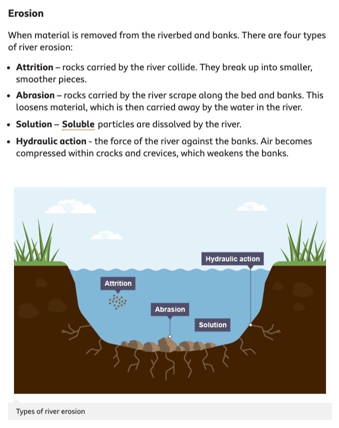
A river removes material from the sides (banks) and bottom (bed) of the river channel. This is called erosion.
The boulders, pebbles, sand, silt and mud are carried downstream. This is called transportation. The material being transported is called the load.
When the river loses energy it deposits material on the river bed. The largest material (boulders) are deposited first.
FACTORS AFFECTING EROSION IN RIVERS
TASK 1: Note the 6 factors affecting erosion in rivers.
There are many factors affecting erosion in rivers. These include:
load – the heavier and sharper the load the greater the potential for erosion
velocity and discharge – the greater the velocity and discharge the greater the potential for erosion
gradient – increased gradient increases the rate of erosion
geology – soft, unconsolidated rocks, such as sand and gravel, are easily eroded
pH – rates of solution are increased when the water is more acidic
human impact – deforestation, dams and bridges interfere with the natural flow of a river and frequently end up increasing the rate of erosion.
PROCESSES OF EROSION AND TRANSPORT IN RIVERS
TASK 2: Draw two labelled diagrams explaining the processes of erosion and transportation.
RIVER EROSION PROCESSES
RIVER TRANSPORT PROCESSES

REVIEW
River Landforms
Identify, describe and explain the formation of river landforms, including: v-shaped valleys, waterfalls, potholes, meanders, oxbow lakes, deltas, levées and flood plains.
River Landforms
Identify, describe and explain the formation of river landforms, including: v-shaped valleys, waterfalls, potholes, meanders, oxbow lakes, deltas, levées and flood plains.
River Landforms
A landform is a physical feature in the land, formed by a physical process. River landforms are caused by the processes of erosion, transportation and deposition.
The main landforms in a river can be divided into two types; those found in the upper valley (highland area) and those found in the lower valley (lowland area).
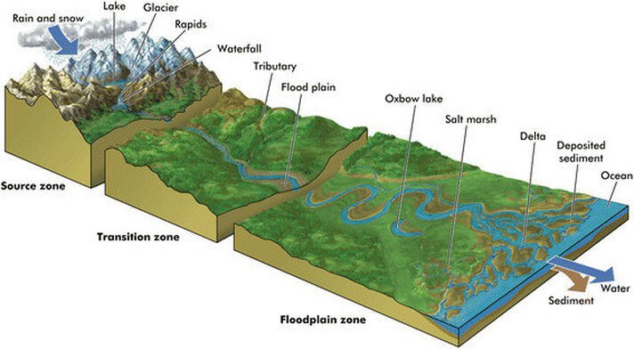

UPPER VALLEY RIVER LANDFORMS
V-SHAPED VALLEY
V-shaped valleys are found near the source of a river, where the river has more energy and is able to erode and transport more material. V-shaped valleys are formed as rivers transport material along their beds, especially by traction and saltation. As this occurs, the material cuts downwards (vertical erosion) relatively quickly, deepening the bed of the river. After periods of heavy rain, soil on the valley sides slowly moves downhill under gravity by rainsplash and soil creep. The valley forms a V-shape as it is deepened faster than it is widened. Interlocking spurs are also formed as the river meanders in the valley, leaving hills, which have not been subject to erosion, jutting out on each side of the river channel

WATERFALLS & GORGES
Waterfalls occur where there is a band of hard rock lying on top of softer rock. The river erodes the softer rock more quickly than the harder rock. This forms a ‘step’ in the river, where the water falls vertically. At the base of the waterfall, the falling water erodes the softer rock and undercuts the hard rock creating an overhang.
Eventually, the overhang will collapse under its own weight. The rocks which break from the overhang forms large blocks at the base of the waterfall. These are slowly broken up by erosion. The loose rocks swirl round at the base of the waterfall and erode a deep plunge pool.
Over many years a gorge will form in front of a waterfall. This is because each time the rock overhand collapses, the waterfall retreats further up the valley. Over many years a steep-sided valley, called a gorge will be created.

POTHOLE

A pothole is a smooth, bowl-shaped or cylindrical hollow, generally deeper than wide, found carved into the rocky bed of a watercourse.
A pothole in a river is typically formed through a natural erosional process known as abrasion. Abrasion occurs when sediment particles, such as sand and pebbles, carried by the river's flow, collide with the riverbed or banks.
Over time, the repeated impact of these particles wears away the bedrock, creating a depression or hole in the riverbed.
LOWER VALLEY RIVER LANDFORMS
MEANDER
A meander is a bend in a river. The river’s flow is fastest on the outside bend of the meander. The outside bend is eroded and undercut to form a river cliff. On the inside bend, the river flows slowly and deposits material. The material builds up to form an area of shallow land, called a slip-off slope.
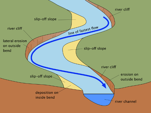
OX-BOW LAKES
During a flood, the narrow neck of land between a meander can be eroded. The river will take the shortest route possible and form a new channel. The old meander becomes cut-off as material is deposited by the river. A lake in the shape of a horse-shoe (known as an ox-bow lake) will be formed. Over time the lake will become marshy and will eventually dry up completely.

FLOOD PLAIN
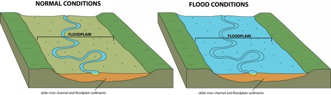
A flood plain is the flat valley floor on either side of a river. Flood plains are formed by erosion and deposition. The river erodes sideways as it meanders downstream. This sideways erosion wears away interlocking spurs in lowland areas and carves out a wide valley. The valley is flooded each year when the river bursts its banks. During the flood, the river deposits layers of stone and mud. The deposited material (alluvium) builds up in layers to form a flat valley floor. Flood plains are excellent places for farming because the soil is very fertile.
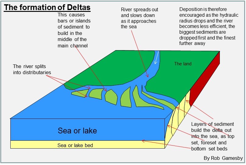
DELTA
When a river reaches the sea, it deposits its entire load except the dissolved load. The heaviest material is deposited first. If the sea is shallow, the deposited material can build up to form a delta. A delta is a low-lying area at a river’s mouth. Often the main river channel splits into many smaller channels. The smaller rivers are called distributaries, and the process is known as braiding
REVIEW
River Hazards
Explain the causes and effects of the 2005 flood in Switzerland
River Hazards
Explain the causes and effects of the 2005 flood in Switzerland
Why is Switzerland at risk from flooding? List human and natural causes of flooding.

The “Wasserschloss” (the confluence of the rivers Aare, Reuss and Limmat in the Canton of Aargau) during the flood of August 2007.
CAUSES OF FLOODING
Create an illustrated mind map to show the physical and human causes of flooding in Switzerland.
Your mind map must include:
Branches which go from thick to thin
Different colours for different branches
An illustration for each piece of information
PHYSICAL CAUSES
Heavy rainfall
Long periods of rain
Saturated ground > less infiltration > more surface runoff
High snow line > precipitation doesn't store as snow
Snowmelt
Steep slopes
Impermeable rock increases runoff
HUMAN CAUSES
Deforestation in ski areas
Soil compaction on ski slopes
Lack of coordination between environmental agencies
Insufficient forecasting and warning
Urbanisation of rural areas
Bridge construction collecting debris blocking river
CASE STUDY: SWISS FLOODS 2005
In August 2005 torrential rain fell for days on end across extensive areas north of the Alps in Switzerland. In some locations, more rain fell than had ever been seen since records have been kept. Within a matter of hours, the water in some lakes reached maximum level, and landslide processes were triggered on numerous slopes. Seven people died. The cost of the material damage caused totalled approximately three billion Swiss francs.
Heavy precipitation on 22nd August 2005
![Up to 200mm of rainfall was received on the northern side of the Alps in 24hrs on the 22nd August, 2005. [Source]](https://images.squarespace-cdn.com/content/v1/53109b11e4b05040160f0a8f/1537966215292-BWRDT9F5DSCJZVSVM0AT/Screen+Shot+2018-09-26+at+14.49.21.png)
Up to 200mm of rainfall was received on the northern side of the Alps in 24hrs on the 22nd August, 2005. [Source]
The River Aare in Switzerland
The Aare River Basin, northern Switzerland.
Read the PDF
Identify causes and effects of the 2005 Swiss floods
Create a case study document on one side of A4
Include a detailed list of causes
Include place-specific detail
Include dates and data e.g. precipitation levels
Include images and maps

REVIEW
With reference to a named example, examine the causes of a river flood (7 marks)
With a partner, note down all the data and evidence you would use to answer this question.
Stream Management Strategies
Explain what can be done to manage the impacts of river flooding
Stream Management Strategies
Explain what can be done to manage the impacts of river flooding

The “Wasserschloss” (the confluence of the rivers Aare, Reuss and Limmat in the Canton of Aargau) during the flood of August 2007.
Brainstorm ways that rivers can be modified to reduce the risk of flooding.
river cross section

web quest: stream management strategies in switzerland
1 - THUn
Management strategies:
- Flood relief tunnel (Thun)
- Channel enlargement (Bern)
2 - stans, nidwalden
Management strategies:
Catchment basin
Flood relief channel
Flood proofing
3 - RIver thur
management strategies:
Channelisation (original management strategy)
River restoration
Groynes/concrete piers
River bank excavation
River bank conservation
Mobile flood embankments
4 - altstatten in st. gallen, burgdorf in bern and wasen in emmental
Management strategies:
Debris removal in Altstatten, St. Gallen
Bridge raising in Burgdorf, Bern
Flood embankments in Burgdorf, Bern
Channel enlargement in Burgdorf, Bern
Catchment basin dam in Altstatten, St. Gallen
Channelisation in Wasen, Emmental
resources


task 1
- Make four groups.
- Each person in the same group watches the same video.
- Work together to complete the grid, using the video and the second sheet to help you.
- Agree on the most important information to share.
Task 2
Make four new groups with mixed members
Share your management strategies with the group
Listen to the other students and complete the grid
