


Atmosphere
Describe the nature and properties of the earth’s atmospheric layers
Atmosphere
Describe the nature and properties of the earth’s atmospheric layers
On 14th October 2012, Felix Baumgartner set a world record by jumping from the furthest point ever in the earth’s atmosphere.

Read this link and watch the two videos below
Complete the writing frame below by adding information about the characteristics of the four layers of the atmosphere, including:
Size
Temperature changes
Boundary names
Unique characteristics e.g. presence of ozone layer
TASK

Atmospheric Circulation
Describe and explain atmospheric circulation
Atmospheric Circulation
Describe and explain atmospheric circulation

Atmospheric circulation is the large-scale movement of air that redistributes heat on Earth. This movement is driven by temperature differences between the equator and the poles. Warm air rises at the equator and cool air sinks at the poles, creating convection cells that circulate air around the planet. There are three major convection cells: the Hadley cell, the Ferrel cell, and the Polar cell.
The Hadley cell is located near the equator and is responsible for the trade winds that blow towards the equator from the northeast and southeast. The Ferrel cell is a mid-latitude cell that is driven by the Hadley and Polar cells. It plays a role in transporting warm air from the tropics and cold air from the poles. The Polar cell is located at the poles and plays a role in transporting cold air to lower latitudes.

ATMOSPHERIC CELLS
TASK 1: Read and watch the information below and add to your notes. Complete the True/False questions below
If the Earth was made only of land and had no spin, rising air at the equator would travel all the way to the poles and sink. However, due to oceans and the rotation of the Earth, multiple cells form. These are called (from the equator to the poles) Hadley cells, ferrel cells and the polar cell.
TRUE/FALSE QUIZ
The purpose of global circulation is to redistribute heat across the Earth. (True/False)
If the Earth was a simple landmass with no oceans, it would have three circulatory cells in each hemisphere. (True/False)
The feral cells are driven by temperature like the Hadley and polar cells. (True/False)
Areas of high pressure receive more rainfall than areas of low pressure. (True/False)
Antarctica is the largest and driest desert in the world.(True/False)
CORIOLIS EFFECT & WINDS
TASK 2: Watch the video and answer the True/false questions below
TRUE/FALSE QUIZ
The global circulation pattern is split into three cells in each hemisphere. (True/False)
The Coriolis effect is caused by a physical force deflecting air movement. (True/False)
The magnitude of the Coriolis force decreases towards the poles. (True/False)
The subtropical jet stream occurs at a height of 11 to 13 kilometers. (True/False)
Jupiter has circulation cells similar to those on Earth due to its fast rotation and strong Coriolis effect. (True/False)
THE JET STREAM
TASK 3: Watch the video and answer the True/false questions below
TRUE/FALSE QUIZ
Jet streams are fast-flowing currents of air found only at high levels in the atmosphere. (True/False)
The major jet streams that circle the earth are found just above the tropopause. (True/False)
The polar front jet occurs over mid-latitudes and strongly influences the weather over the UK in Europe. (True/False)
The temperature gradient produces a pressure gradient force that theoretically causes air to flow from north to south in the Northern Hemisphere. (True/False)
The jet stream is stronger in the summer than in the winter due to the stronger temperature contrast. (True/False)
THE INTER-TROPICAL CONVERGENCE ZONE (ITCZ)
The Intertropical Convergence Zone, or ITCZ, is a band of low pressure around the Earth which generally lies near to the equator. The trade winds of the northern and southern hemispheres come together here, which leads to the development of frequent thunderstorms and heavy rain. These thunderstorms can reach, and sometimes exceed, 16 kilometres, 55,000 feet or 10 miles in height above the surface. (Source)

A band of clouds circling the equator marking the position of the ITCZ

Diagram showing the position of the ITCZ, Horse Latitudes and Polar Front
The air that is forced to rise along the ITCZ moves towards the poles and slowly descends leading to large areas of high pressure in the sub-tropics, sometimes known as the horse latitudes, and bring largely benign weather conditions to places like the Azores. The resulting circulation that forms with air converging near the surface around the equator and diverging above is known as the Hadley Cell.

The ITCZ moves throughout the year and follows the migration of the Sun’s overhead position typically with a delay of around 1-2 months. As the ocean heats up more slowly than land, the ITCZ tends to move further north and south over land areas than that over water. In July and August, the ITCZ lies well to the north of the equator over Africa, Asia and Central America before moving south into South America, central Africa and Australia by January and February.
Another term for the ITCZ, used historically in seafaring circles, is the ‘doldrums’ since the winds along the band of low pressure are typically calm, trapping ships for days or even weeks at time leaving them stranded.
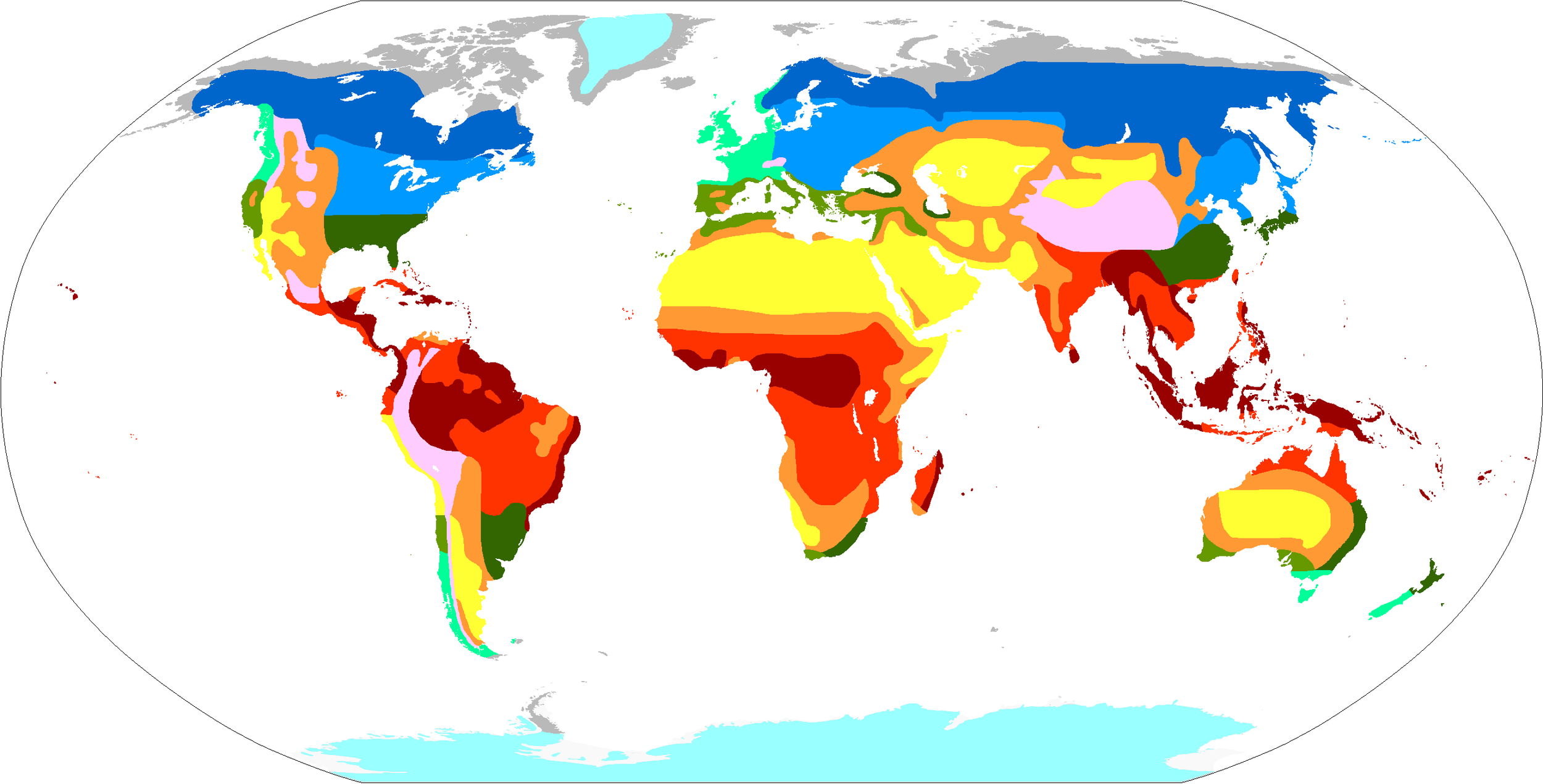
Factors Affecting Climate
Describe and explain the factors affecting climate: latitude, distance from the sea, prevailing winds, ocean currents, relief, altitude.
Factors Affecting Climate
Describe and explain the factors affecting climate: latitude, distance from the sea, prevailing winds, ocean currents, relief, altitude.
Explain the reasons for the differences in Europe’s climate as shown on the map. Discuss and write 3 fully developed ideas into your notes.

WEATHER & CLIMATE
TASK 1: Define weather and climate
Weather and climate are two terms that are often used interchangeably, but they are actually quite different.
Weather refers to the short-term atmospheric conditions of a specific area, including temperature, humidity, precipitation, wind speed and direction, and atmospheric pressure.
Climate, on the other hand, refers to the long-term patterns and trends of weather conditions in a particular area, including average temperature, precipitation, and wind patterns.
factors affectING climate
Latitude
Latitude refers to the distance north or south of the equator. Areas closer to the equator receive more direct sunlight and therefore tend to be warmer, while areas farther from the equator receive less direct sunlight and tend to be cooler. As a result, the temperature and climate vary significantly depending on the latitude of a location.
Distance from the sea
Areas near the coast tend to have a more moderate climate because the ocean helps regulate temperature by absorbing and releasing heat. Inland areas, on the other hand, have a more extreme climate, with hot summers and cold winters. The distance from the sea can also affect the amount of precipitation a region receives.
Prevailing winds
Prevailing winds are the dominant winds in a particular area. These winds can bring moisture and change the temperature of a region. For example, the prevailing winds in California are from the west, bringing cool, moist air from the Pacific Ocean, which helps moderate the climate of the state.
Ocean currents
Ocean currents are large-scale movements of water in the ocean. These currents can affect the temperature and precipitation of coastal regions. For example, the Gulf Stream is a warm ocean current that brings warm water from the Gulf of Mexico to the east coast of North America, helping to moderate the climate of the region.
Altitude
Altitude refers to the height above sea level. As altitude increases, the air becomes less dense, and the temperature drops. Therefore, areas at higher altitudes tend to be colder than areas at lower altitudes. For example, mountainous regions tend to have colder climates than low-lying areas at the same latitude.

Air Masses
Describe air masses and explain how their interaction creates depressions and anticyclones
Air Masses
Describe air masses and explain how their interaction creates depressions and anticyclones
What is this and what could have caused it?

AIR MASSES
TASK 1: Draw a simple diagram show the types of air masses and the weather they bring.

WEATHER FRONTS
TASK 2: Watch the video. Draw the 3 types of front. Explain what happens when air masses meet.
DEPRESSIONS & ANTICYCLONES
TASK 3: Make a simple sketch of the diagrams below.

DEPRESSIONS
TASK 4: Briefly explain what a depression is using the text below.
In meteorology, a depression is a region of low atmospheric pressure relative to the surrounding areas. It is also known as a low-pressure system or a cyclone.
In a depression, air is rising from the surface of the Earth, causing the pressure to decrease. This creates a zone of unstable weather conditions, such as cloudy and rainy weather, strong winds, and sometimes thunderstorms.
Depressions can be large-scale weather systems that span hundreds or even thousands of kilometers, or they can be smaller, localized features. They are often associated with the movement of cold and warm air masses and can occur in both the tropics and mid-latitudes.
The opposite of a depression is an anticyclone, which is a region of high atmospheric pressure.
TASK 5: Watch the video and draw a labelled cross section of a depression

SYNOPTIC CHARTS
A synoptic chart, or weather map, shows the current state of the atmosphere in terms of air pressure, air masses and cold, warm and occluded fronts.