


Earth Structure
Describe the internal structure and layers of the earth
Explain how the internal structure of the earth creates plate movement
Earth Structure
Describe the internal structure and layers of the earth
Explain how the internal structure of the earth creates plate movement
EARTH STRUCTURE
TASK 1: Add labels to a diagram of the earth's internal structure using information below
The Earth is made up of several layers:
The crust: The Earth's crust is the outermost layer and is composed of solid rock. It includes both the continental crust, which forms the continents, and the oceanic crust, which underlies the ocean basins. The continental crust is thicker (up to 70 kilometers) compared to the oceanic crust (around 7-10 kilometers).
The mantle: The mantle is primarily composed of solid rock that can flow over geological timescales. It contains minerals rich in iron, magnesium, and silicon. the upper part of the mantle is rigid, the lower mantle is semi-fluid and can flow slowly over time, leading to the movement of tectonic plates.
The outer core: The outer core is the layer of the Earth below the mantle. It is made up of liquid iron and nickel and is the source of the Earth's magnetic field.
The inner core: The inner core is the innermost layer of the Earth. It is made up of solid iron and nickel and is the hottest part of the Earth, with temperatures reaching up to 5,500 degrees Celsius.
P-WAVES & S-WAVES
Earthquakes release P-waves (primary waves) and S-waves (secondary waves). They are used to study the internal structure of the Earth because they travel through the Earth at different speeds and are affected by different materials in the Earth.
P-waves are compression waves that can travel through both solid and liquid materials. They are the fastest type of seismic wave and are the first to arrive at a seismograph (instrument used to measure earthquakes). P-waves can pass through the Earth's core and are used to study the outer core and the mantle.
S-waves are shear waves that can only travel through solid materials. They are slower than P-waves and arrive at a seismograph after the P-waves. Because S-waves cannot pass through the Earth's liquid outer core, their presence or absence can be used to infer the presence or absence of a liquid outer core. S-waves are also used to study the Earth's crust and mantle.
By studying the characteristics of P-waves and S-waves, scientists can learn about the composition, density, and temperature of the different layers of the Earth, as well as the depth and size of earthquakes.

convection currents
TASK 2: Explain how convection currents in the mantle lead to plate movement.
Convection currents are caused by the movement of hot and cold materials within the Earth's mantle. These currents can be thought of as a type of "conveyor belt" that transports heat from the interior of the Earth to the surface. As the hot material rises, it cools and becomes denser, causing it to sink back down towards the interior. This constant circulation of hot and cold material creates a driving force that can push the Earth's tectonic plates. In turn, this movement of the plates leads to the creation of earthquakes, volcanoes, and mountain ranges.

THE EVIDENCE FOR CONTINENTAL DRIFT THEORY
Continental drift is the theory that the Earth's continents have moved over time and are still moving today. It proposes that the continents were once part of a supercontinent called Pangaea and have since drifted apart due to the movement of the Earth's tectonic plates.
The theory of continental drift was first proposed by Alfred Wegener in the early 20th century, but it was not widely accepted until the 1950s, when the theory of plate tectonics was developed.
There are several pieces of evidence that support this theory:

1) Fit of the continents - the continents fit together like puzzle pieces, the shapes of their coastlines match up remarkably well.
2) Fossil evidence - fossils of the same species have been found on different continents, suggesting that these continents were once connected.
3) Rock formations - similar rock formations are found on different continents, indicating that these continents were once part of the same landmass.
4) Paleomagnetism - the Earth's magnetic field periodically reverses direction. When this occurs, the magnetic minerals in rocks become aligned with the Earth's new magnetic field. By studying the orientation of these minerals in rock formations, it is possible to determine the location of the rock when it was formed. This has shown that the continents have moved over time.
Tectonic Plates
Describe and explain the distribution of earthquakes and volcanoes
Tectonic Plates
Describe and explain the distribution of earthquakes and volcanoes
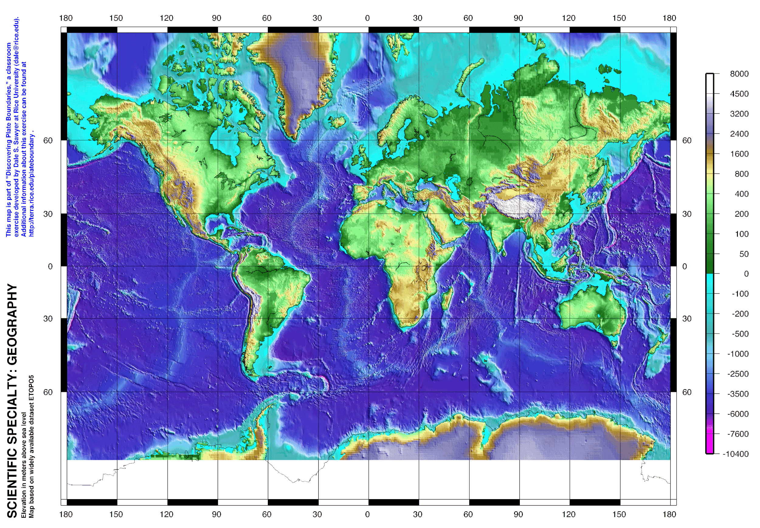
TASK 1: Using Atlas Mondiale Suisse:
Indicate the following features on the blank map:
Hot spot
Continental Rift
Sea-floor spreading
Subduction zone
Fold mountains
Add the names of the plates
Add a key / legend and an appropriate title
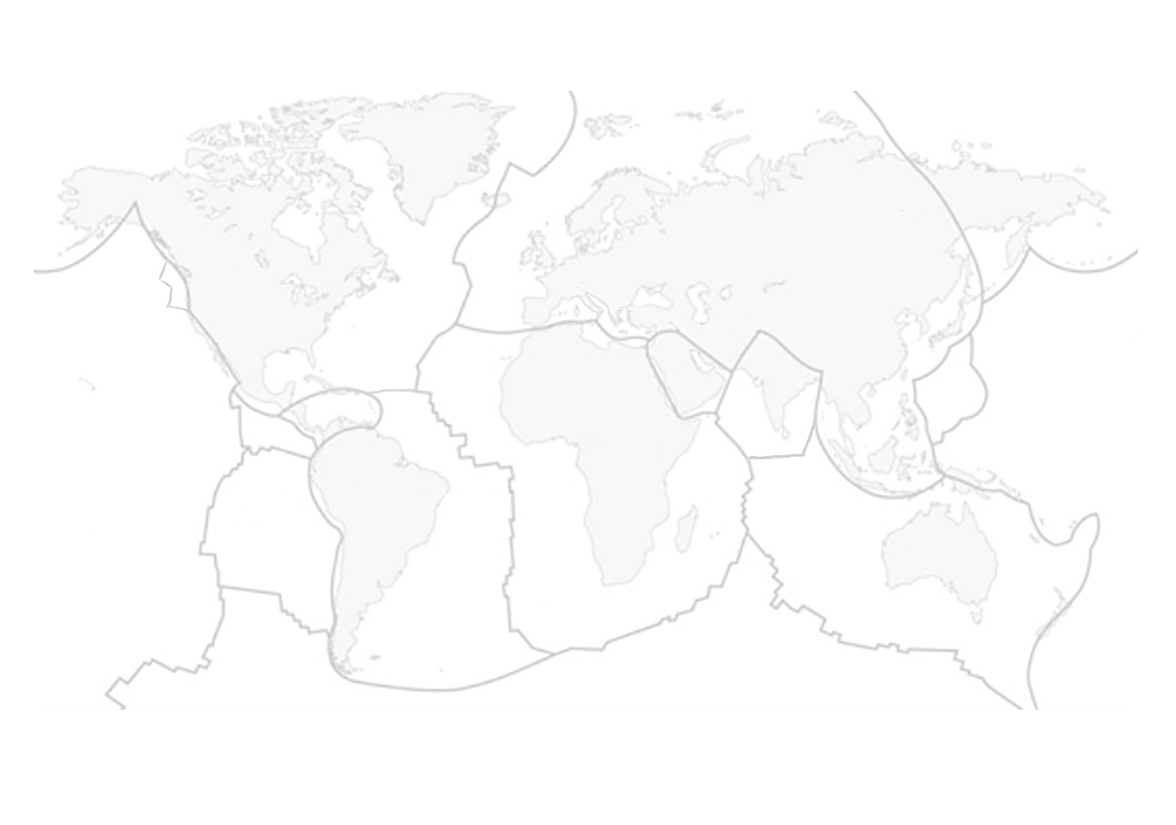
TASK 2: Test your knowledge of the tectonic plates using the activity below


TASK 3: Study the maps below and add labels to your map showing what these different maps tell us about plate tectonics
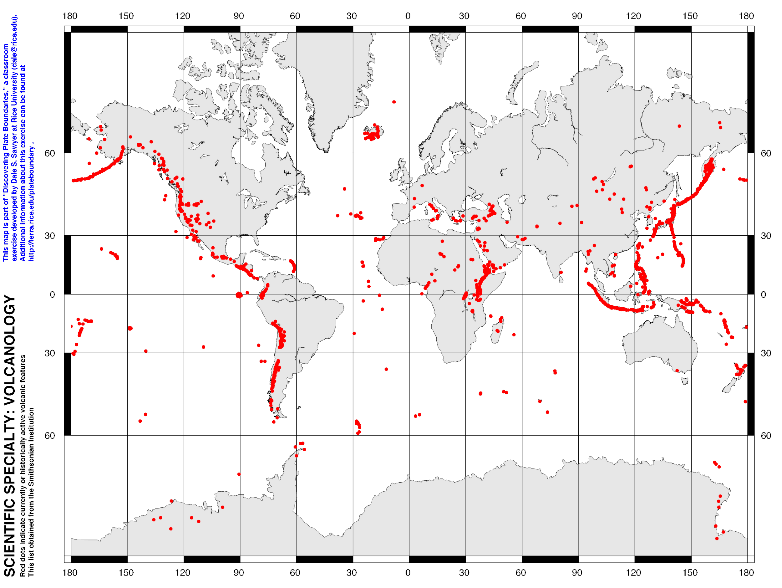
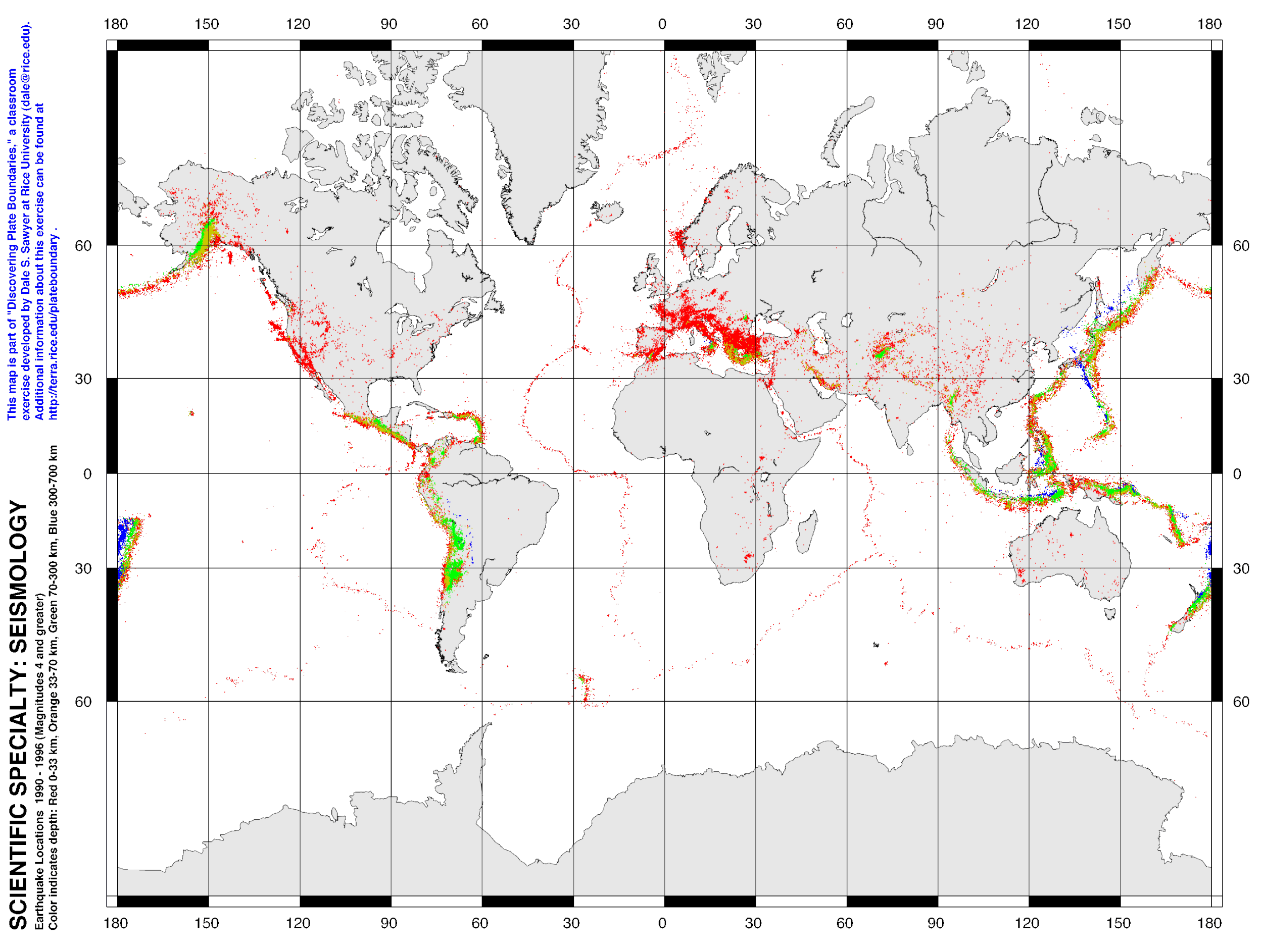
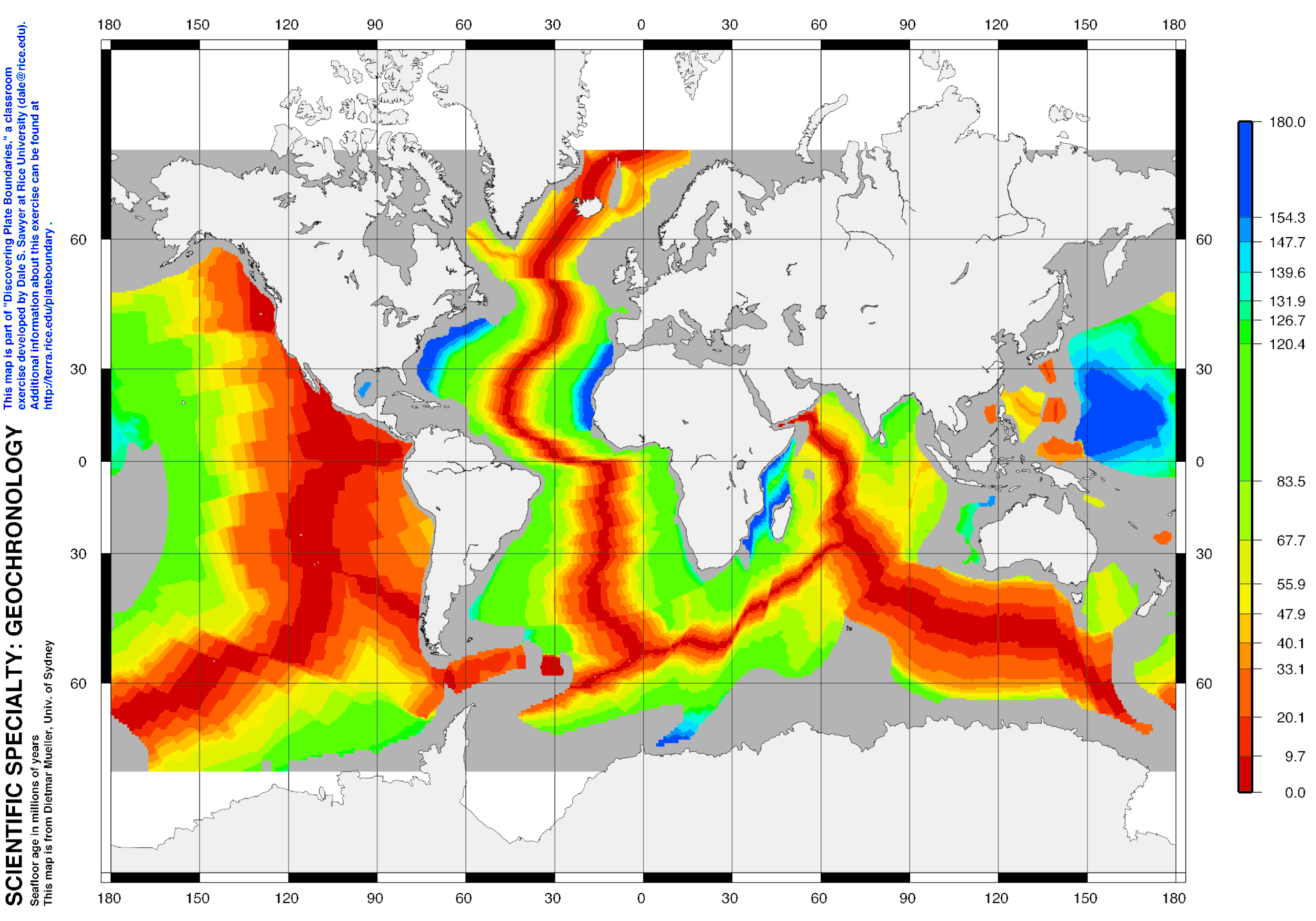
In your groups:
Work out what is happening on your map. Read the title and key.
When you are sure about your map, show the global patterns by drawing on your blank plate boundary map using colour pens.
Include a key to show what the colours mean.
LEARN
TEST
Plate Boundaries
Describe plates and their movements (divergent, convergent and constructive)
Plate Boundaries
Describe plates and their movements (divergent, convergent and constructive)
![A diver swims between the North Amercian and Eurasian plate on the constructive plate boundary in Iceland [Source]](https://images.squarespace-cdn.com/content/v1/53109b11e4b05040160f0a8f/1493654368597-RK8JN2KNMV7LCHK4FF2I/image-asset.jpeg)
A diver swims between the North Amercian and Eurasian plate on the constructive plate boundary in Iceland [Source]
THE LITHOSPHERE
The lithosphere is the outermost solid layer of the Earth, comprising the crust and the upper mantle. It is the layer of the Earth that we live on and is made up of solid rock.
The lithosphere is divided into 6 main tectonic plates, which are in constant motion due to the convection currents in the mantle. The lithosphere is made up of a variety of rock types, including igneous, sedimentary, and metamorphic rocks.
THE CRUST
The crust is the outermost layer of the Earth and is made up of solid rock. It is divided into two types: continental crust and oceanic crust.
Continental crust is the top layer of the Earth's crust. It is made up of granitic and sedimentary rocks and is generally thicker and less dense than oceanic crust. Continental crust ranges in thickness from 35 to 70 kilometers and makes up about 29% of the Earth's crust.
Oceanic crust is the layer of the Earth's crust found under the oceans. It is made up of basaltic rock and is generally thinner and denser than continental crust. Oceanic crust ranges in thickness from 7 to 10 kilometers (4 to 6 miles) and makes up about 71% of the Earth's crust.
Both types of crust are constantly moving due to the convection currents in the mantle, but oceanic crust is more dense and sinks more easily, causing it to be recycled back into the mantle. Continental crust, on the other hand, is less dense and is more likely to be uplifted and transformed into mountains.
PLATE BOUNDARIES
There are four main types of plate boundaries:
Constructive (divergent)
Destructive (convergent)
Collision (convergent)
Conservative
Constructive (or divergent) boundaries occur where two plates are moving away from each other. At these boundaries, new crust is generated as magma rises to the surface and solidifies. This is how oceanic crust is formed at mid-ocean ridges. As the plates move apart, magma rises to fill the gap and solidifies to form new oceanic crust. This process can also lead to the formation of rift valleys and underwater mountain ranges.
Destructive (or subduction) boundaries occur where two plates are converging, with one plate being pushed beneath the other. This process is known as subduction and it typically occurs when an oceanic plate meets a continental plate. The denser oceanic plate sinks beneath the continental plate and is recycled back into the Earth's mantle. As the plate descends deeper into the Earth, it can cause earthquakes, volcanoes, and mountain building.
Collision boundaries also occur when two plates converge, but in this case, both plates are typically continental plates. They push against each other and can cause the formation of large mountain ranges, like the Himalayas.
Conservative boundaries occur where two plates are sliding past each other horizontally. This process is known as strike-slip faulting, and it can cause earthquakes. Transform boundaries, such as the San Andreas Fault in California, are examples of conservative plate boundaries. These boundaries are also referred to as "conservative" because the plates themselves are not destroyed, but instead move along the boundary.
TEST YOURSELF

Complete the quiz
Types of Volcanoes & Eruptions
Describe and explain different types of volcanoes and eruptions
Types of Volcanoes & Eruptions
Describe and explain different types of volcanoes and eruptions
KEY WORDS
Effusive - relating to the eruption of large volumes of molten rock
Viscous - having a thick, sticky consistency between solid and liquid; having a high viscosity
Basalt - a fine-grained, dark-colored, volcanic rock which is the most common type of rock in the Earth's oceanic crust and forms from rapidly cooled lava flows. Basalt has a low silica content, making it less viscous than other types of volcanic rocks, and it is often associated with shield volcanoes.
TECTONICS, LAVA AND VOLCANO TYPES
TASK 1: Watch the video and make notes on the different types of lava

TYPES OF VOLCANO
TASK 2: Read the text, watch the video and add labels to your diagram of the different volcano types
There are several types of volcanoes with distinct characteristics that set them apart from each other:
Shield Volcanoes: These are large, broad and gently sloping volcanoes shaped like a cone. They are mostly made up of fluid basaltic lava flows, which spread out in all directions from the vent.
Cinder Cone Volcanoes: These are small, steep-sided cones shaped like a volcano, composed of solidified volcanic ash and cinders. They are typically formed from explosive eruptions that propel ash, cinders, and other volcanic fragments into the air.
Composite Volcanoes (Stratovolcanoes): These are tall, cone-shaped volcanoes built up by alternating layers of solidified ash, lava, and volcanic rocks. They are the result of repeated eruptions over time and can grow to be very large, sometimes reaching heights of several kilometers.
Caldera Volcanoes: These are large volcanic craters formed by the collapse of a volcano's summit. They are created when the magma chamber beneath the volcano drains, causing the surface to sink and collapse.
Lava Dome Volcanoes: These are dome-shaped structures formed by slow-moving, viscous lava flows that pile up and eventually solidify into a dome. Unlike other types of volcanoes, lava dome eruptions are not explosive and do not produce ash or pyroclastic flows.
Submarine Volcanoes: These are underwater volcanoes that form along the ocean floor. They are typically less well-studied than their above-water counterparts due to the challenges of observing and accessing them, but are thought to play an important role in shaping the Earth's crust and climate.
TYPES OF ERUPTION
TASK 3: Research the different types of volcanic eruption and add labels to the diagram below

REVIEW
TASK 4: Complete the activity below
Volcano Hazards & Opportunities
Demonstrate an understanding that volcanoes present hazards and offer opportunities for people
Volcano Hazards & Opportunities
Demonstrate an understanding that volcanoes present hazards and offer opportunities for people
Measuring Earthquakes
Compare and contrast the Richter and Mercalli scales
Measuring Earthquakes
Compare and contrast the Richter and Mercalli scales
richter scale
Measures magnitude of earthquakes (strength and force)
1935 - Charles Richter
Measured on seismometer and shown on a seismograph
Logarithmic - each point is 10 times stronger than before e.g 6.0 is 10 times stronger than 5.0

mercalli scale
Measures intensity of earthquakes
1906 - Giuseppe Mercalli
Measured by effects on man made structures and the environment
Effects may be different with distance from earthquake


task
Draw a labelled diagram of a shield and composite volcano. Explain how they are formed by reading p 80.
Explain how the Richter and Mercalli scales are similar and different (compare and contrast) by completing a Venn diagram. Use the information above.
Illustrate the different impacts on the Mercalli scale storyboard by drawing pictures.
Earthquake Example
Describe and explain the causes and effects of a famous earthquake event
Earthquake Example
Describe and explain the causes and effects of a famous earthquake event
Can you remember any famous earthquakes? What do you remember about the event?